PROJECT TEAMS' RESULTS
Five alternative visions – this is what the project teams developed during the concept development phase of the North Lviv test planning process. On June 29, 2026, the teams presented their concepts at the final workshop. Each one takes a distinct approach to transforming the area, from the structure of public spaces to transport mobility and ecological solutions.
Next comes the consolidation phase, where the five concepts will be brought together into a single vision for the area’s development – one that combines the teams’ ideas, expert recommendations, and residents’ feedback.
Team 1
Hosoya Schaefer Architects • Zurich • + ATO-Bel Architects • Lviv •
More about the team's concept
Unbroken Commons
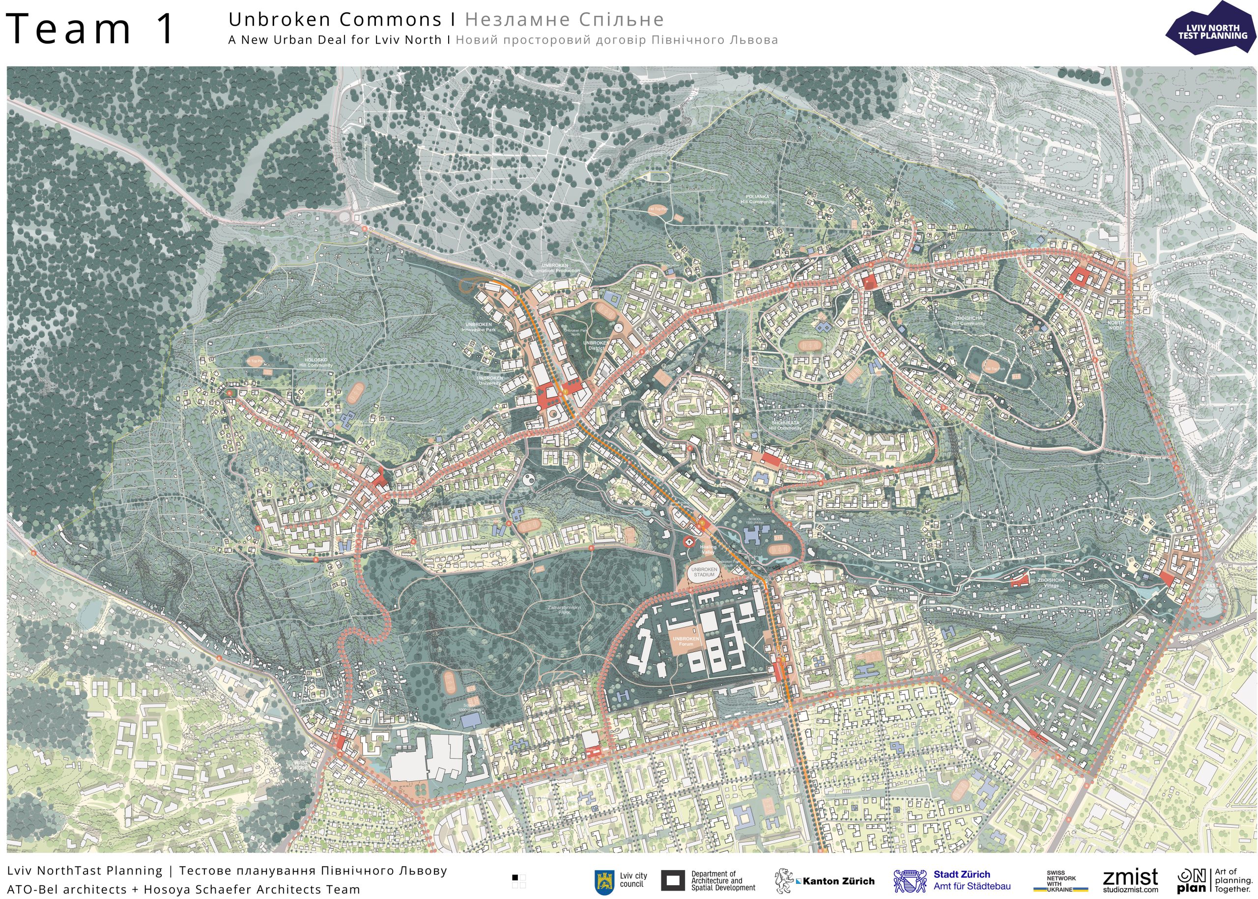
Unbroken Commons is the team’s project concept, built to strengthen collaboration, resilience, and shared responsibility. Lviv North is envisioned as a place where reconstruction becomes a process of healing. There the rebuilding the physical environment goes hand in hand with building new relationships between people, institutions, and the city.
The concept draws on the Japanese art of kintsugi – repairing broken pottery by highlighting the cracks in gold rather than hiding them. In the same way, reconstruction shouldn’t erase the marks left by war. Instead, it should turn them into the foundation for a stronger, more resilient urban fabric. The team treats reconstruction as a process of healing, adaptation, and collective learning.
The project is designed for both current residents and future communities: veterans, patients, students, entrepreneurs, families, and visitors. It builds on strengths Ukrainian society already has – democracy, self-organization, innovation, and social cohesion – and turns them into shared urban structure. At its core is the UNBROKEN ecosystem, bringing healing, learning, work, and daily life together into one whole. At the same time, the project protects and strengthens existing neighborhoods, so today’s residents become active participants in shaping the district’s future.
The concept brings landscape, mobility, community development, and institutional innovation together into one system for long-term growth. A continuous green network of valleys, forests, parks, and protected hilltops forms the district’s ecological backbone. The Unbroken Spine – an urban artery running along the UNBROKEN ecosystem – links healthcare, education, innovation, housing, and public space into a living urban corridor, supported by a new tram line and a network of walkable neighborhoods.
Through collaboration instead of fragmentation, and participation instead of top-down planning, North Lviv becomes a prototype for democratic reconstruction, an example of how resilient communities, healthy landscapes, and innovative institutions can shape Ukraine’s future.
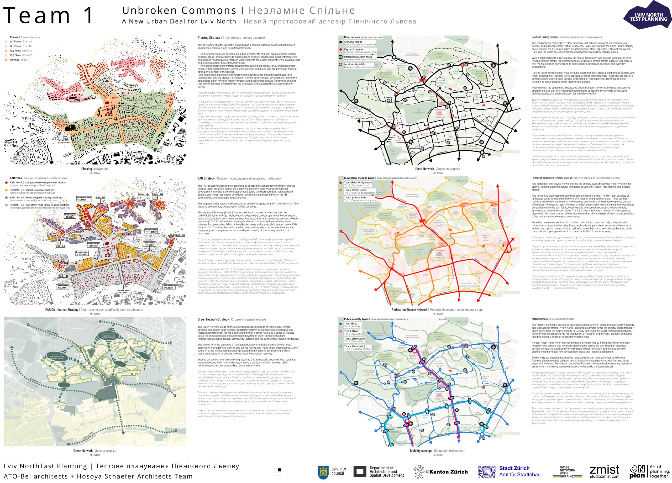
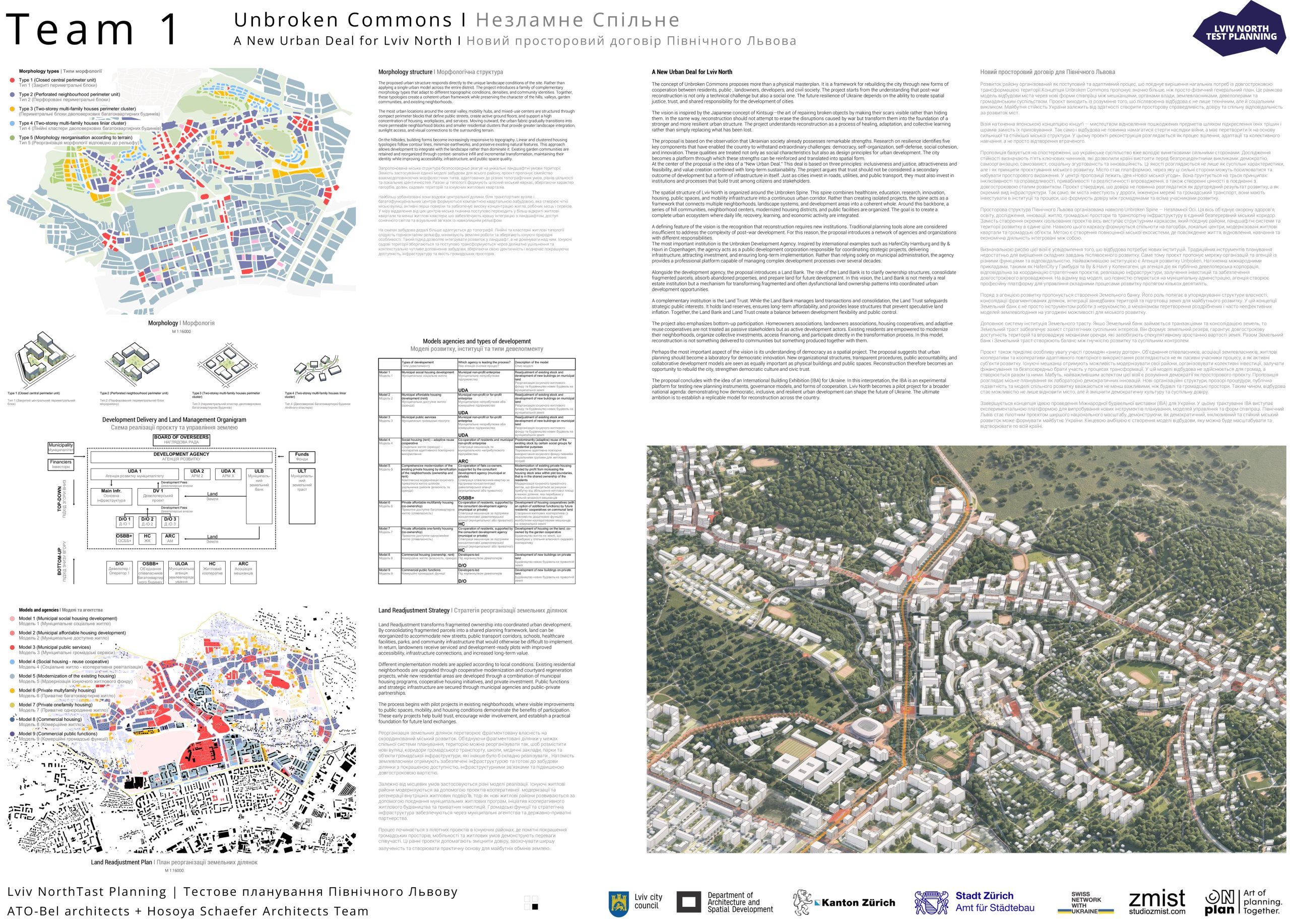
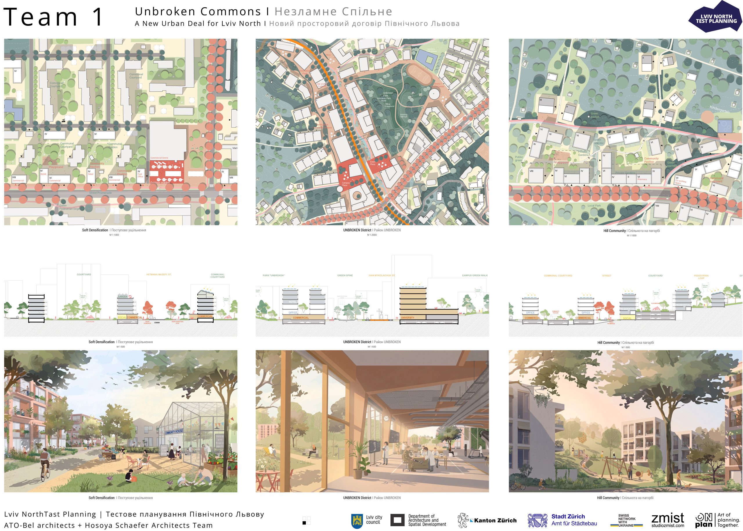
Images are shown here in compressed format. You can view and download the full high-resolution materials here
Team 2
agence ter • France • + Martin Duplantier Architectes • France | Lviv • + burø • Kyiv • + urbanideas • Lviv • + Room 66 Studio • Lviv •
More about the team's concept
Nature as a Horizon
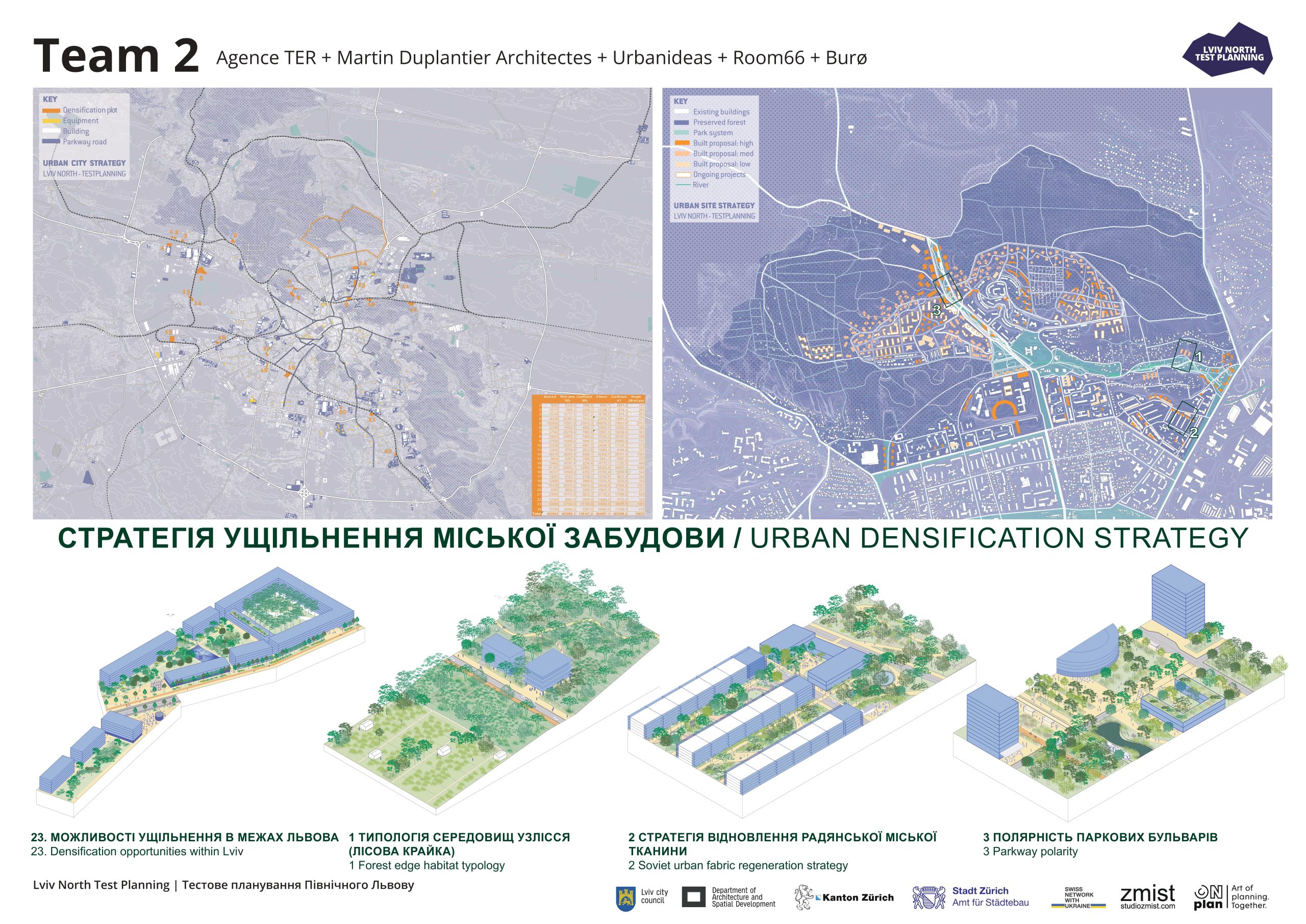
The team’s premise: Lviv’s northern edge is a living landscape, one worth revealing, protecting, and strengthening. The hills and forested horizon here form the city’s structural backbone. The project deliberately draws a firm line around urban sprawl: growth doesn’t happen through new land, but within the built-up area, through densification and rethinking the existing urban fabric.
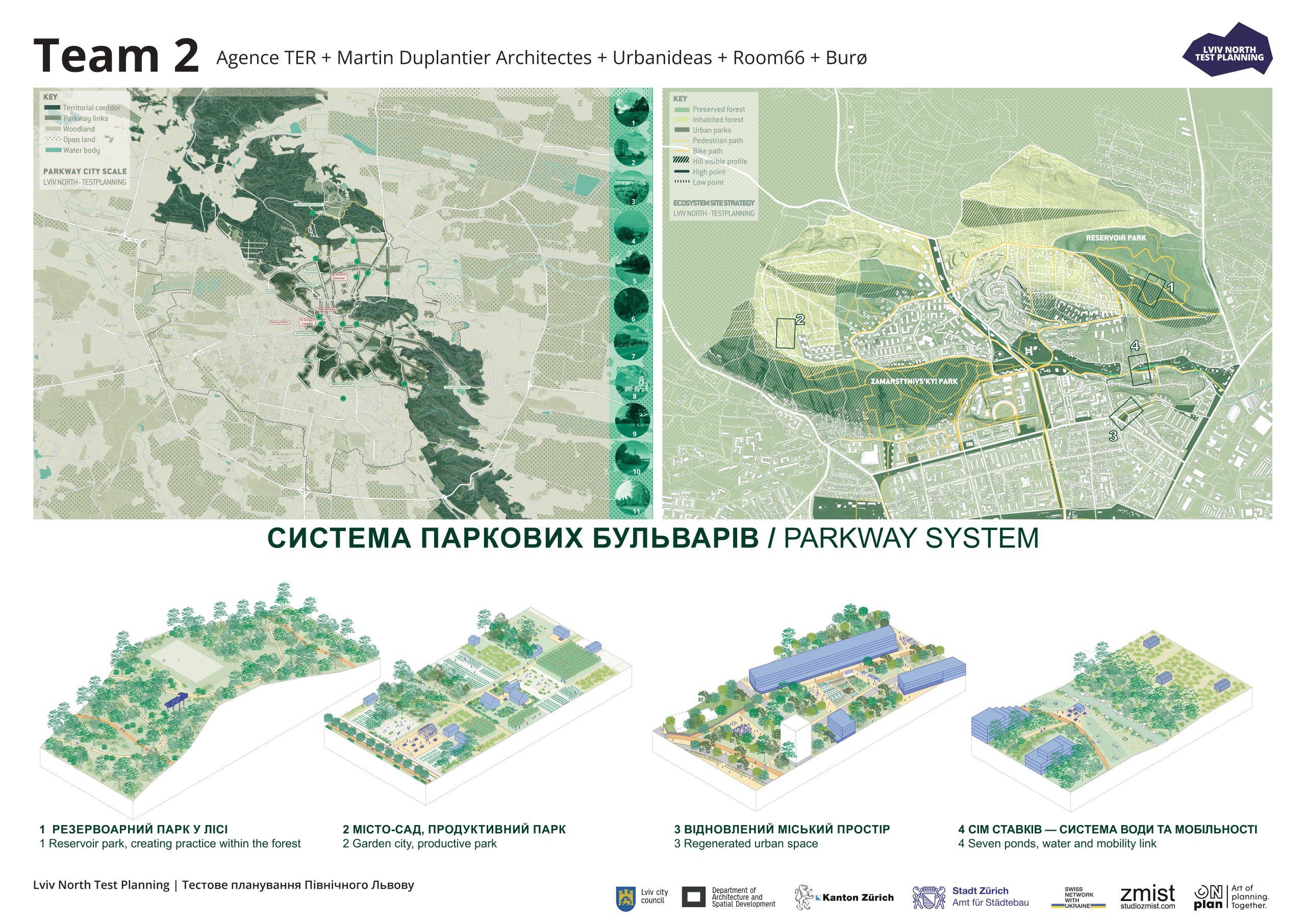
From the hills, a network of green corridors – parkways – extends into the city, carrying soil, water, biodiversity, and movement with them. These aren’t infrastructure in the usual sense, but spaces for a slower, calmer kind of life. They’re places for meeting and shared use, stitching the city’s scattered parts into one accessible, living system.
New development grows along these lines. On Mykolaichuka Street, density doesn’t conflict with nature. Housing and community clusters sit directly within the landscape, forming an “ecosystem for living,” where the urban environment develops in direct contact with natural processes. The line between campus and city dissolves into a single living organism.
The team proposes a hybrid city that doesn’t push out the forest edge. New development responds to the terrain, topography, and existing ecosystems. The edge stops being a line of rupture and becomes a zone of interaction.
Recognizing the value of what already exists is central. Existing neighborhoods, their everyday practices and rhythms, form the project’s foundation. Special attention goes to residents’ vegetable gardens and household plots, treated as living structures worth preserving and strengthening, where private initiative and shared life meet, and where the area’s identity runs deepest.
A city that grows inward, connects outward, and lives in harmony with its landscape.
Five urban approaches to densification:
Urban Regeneration – intensifying nature and function within already built-up areas through extensions and additions. Can accommodate over 2,700 new residents within the existing built environment, significantly improving quality of life.
Forest Edge Urban Deployment – a clear urban boundary shaped by terrain and ecological conditions. Housing gradually steps down in height along the slope, creating a smooth transition from city to forest.
Garden City – a community-driven approach that preserves existing practices and landscape qualities through a modular architectural system. Develops productive landscapes, including urban agriculture, strengthening social cohesion and ecological resilience.
Parkway – a system of nodes along the parkways near tram stops, combining services and public facilities to create a distinct urban identity and a series of active public spaces.
Seven Ponds – daylighting streams to create a continuous water-and-forest landscape, complemented by a network for walking and cycling. Forms a distinctive, recognizable gateway to the park.
Nature:
The terrain and topography of the hills form a cross-cutting ecological corridor of metropolitan significance, a key element of the North Lviv area that needs to stay undeveloped to preserve ecological integrity and landscape identity. Natural areas gain a network of trails and a considered activity program (outdoor sports, contemplative spots, educational spaces), balancing accessibility with conservation.
Mobility:
Expanding the tram network and creating a through ring road connecting the eastern and western parts of the area play a key role. Rather than pushing the city outward, this establishes a clear boundary and supports circular movement, drawing people back into the park-and-tram system. The park network shapes the everyday experience of getting around the city. From your own doorstep to anywhere in the city, the journey becomes a smooth mix of walking, cycling, and transit, always in contact with nature. The main arteries – Hetmana Mazepy and Ivan Mykolaichuk streets – become both zones of thoughtful densification and green corridors supporting biodiversity and sustainable mobility.
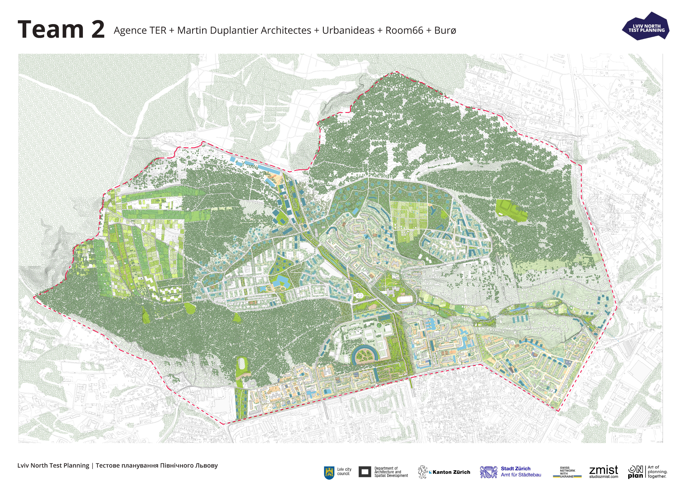
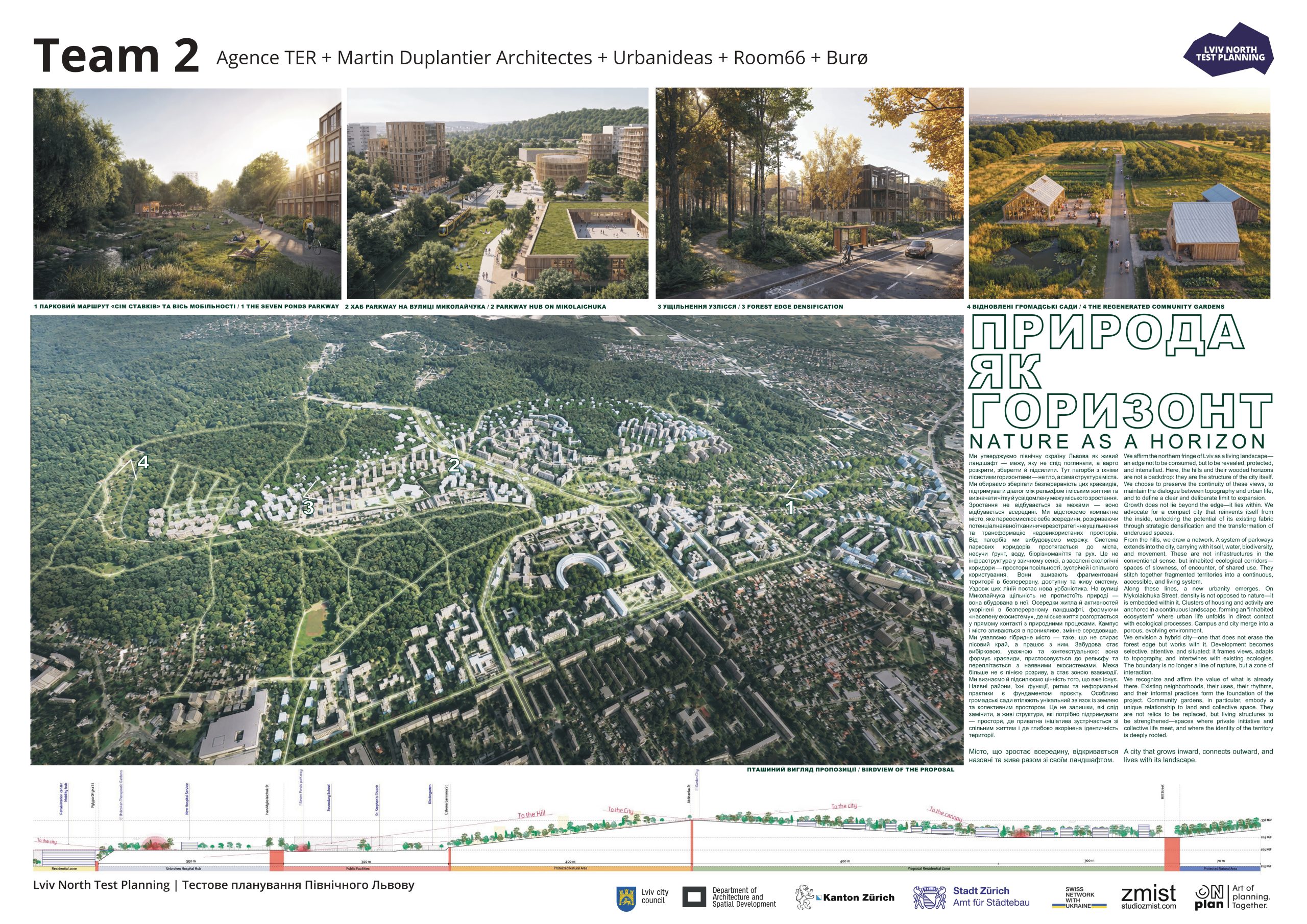
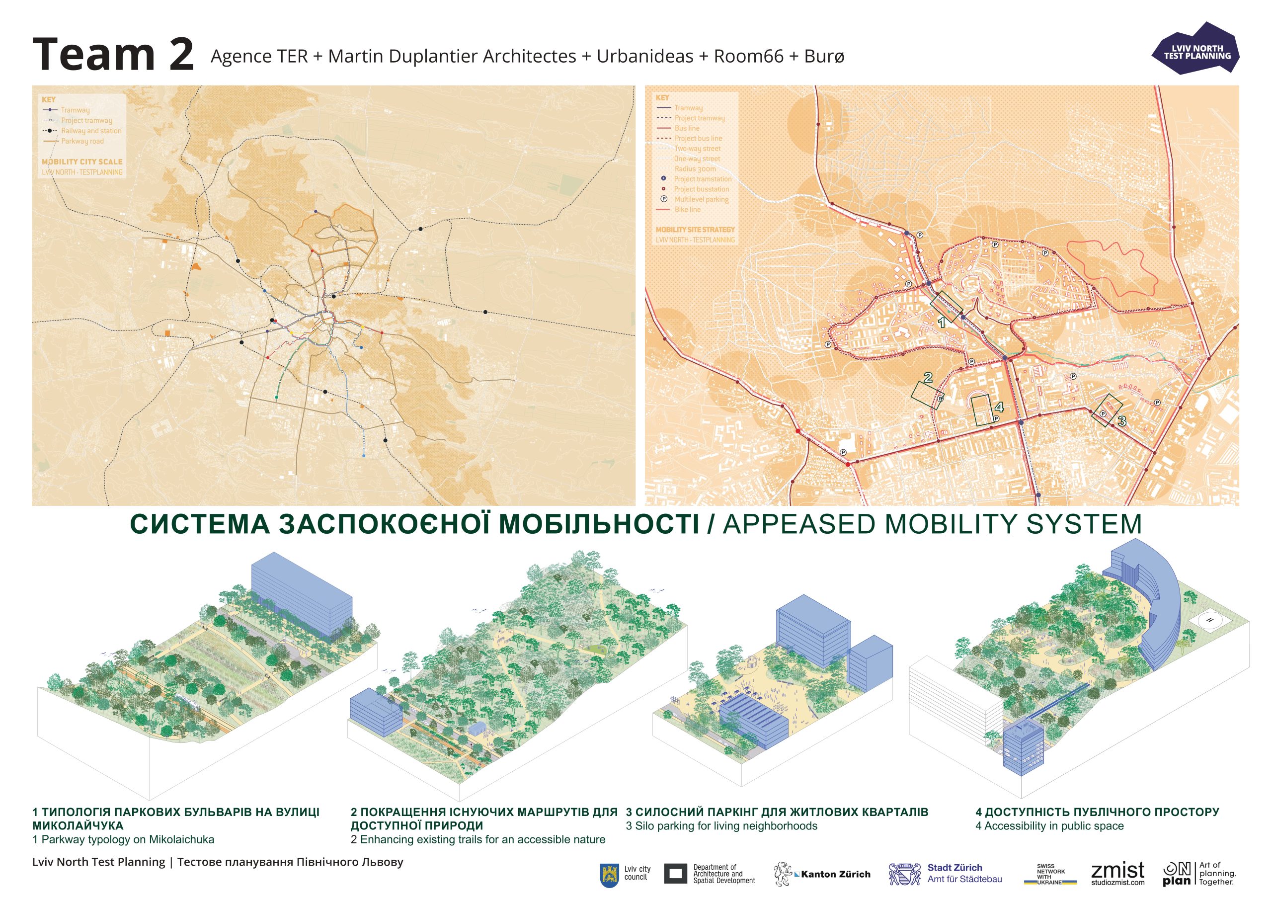
Images are shown here in compressed format. You can view and download the full high-resolution materials here.
Team 3
Karres en Brands • Nederlands • + Drozdov & Partners • Lviv •
More about the team's concept
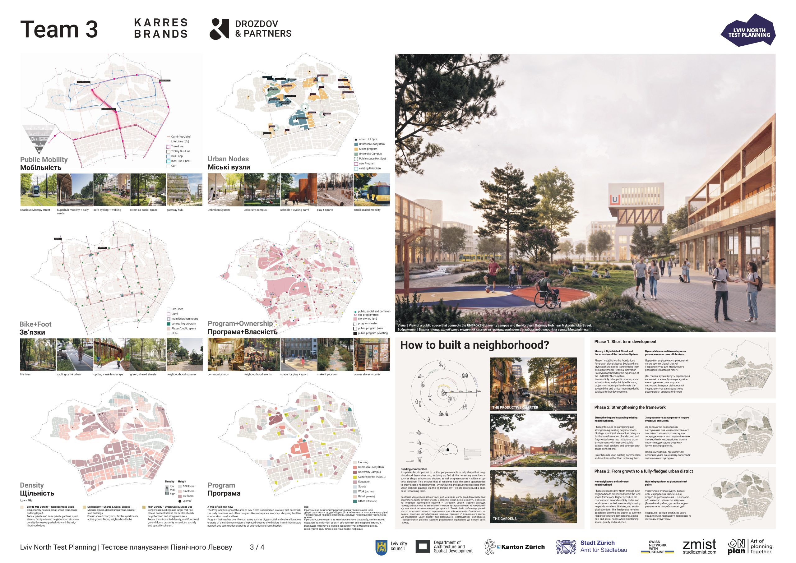
City of Communities
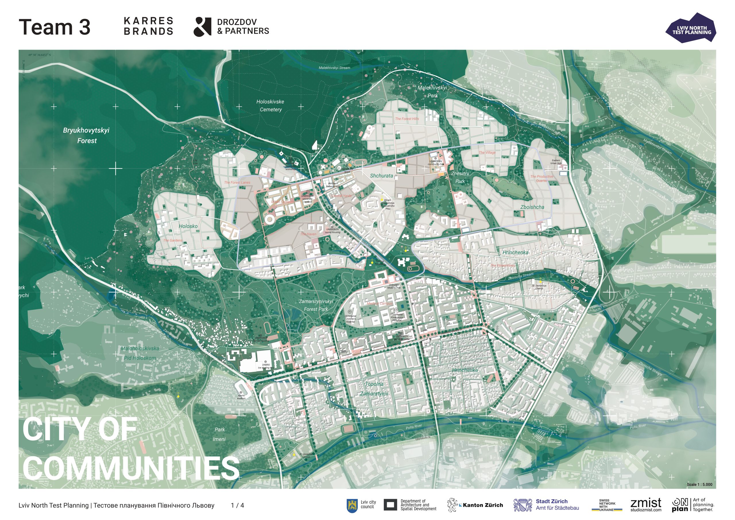
The team’s concept treats Lviv North as a long-term, adaptive process, one where quality of life, social cohesion, and landscape drive the area’s spatial development.
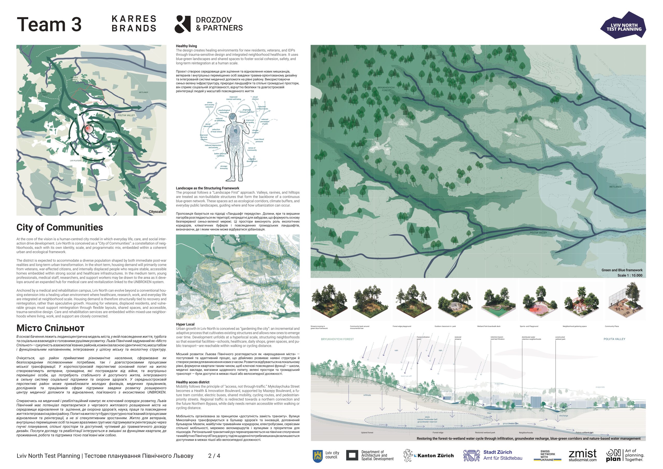
At its core is a human-centered model: North Lviv is envisioned as a City of Communities – a set of districts, each with its own identity and scale, brought together into one coherent urban and ecological structure. A network of green corridors, valleys, and hills forms a system of “community islands”: human-scale districts where landscape shapes community and ensures equal access to nature and public space.
The team expects the district to first serve veterans, war-affected residents, and IDPs who need affordable housing and healthcare infrastructure. Over time, it’s expected to attract young professionals, medical staff, and researchers as the UNBROKEN ecosystem grows.
Landscape First
Valleys, ravines, hilltops, forests, wetlands, and the Poltva basin stay undeveloped, forming a continuous blue-green network. Rainwater collects in the forested highlands, flows through valley corridors, and gathers in the Poltva wetlands, which act as a natural sponge, reducing flood risk and supporting biodiversity. These corridors also serve a social function, hosting walking and cycling routes, parks, gardens, and urban farming.
Spatial structure
The district is designed as a Healthy Access District – a compact, transit-oriented expansion for 62,800-86,400 residents. Mykolaichuk Street becomes a Health and Innovation Boulevard, with a tram corridor, cycling infrastructure, and healthcare and education facilities. Together with Mazepy Boulevard, it forms the district’s main backbone. Mobility follows an “access, not through-traffic” principle: regional traffic is routed onto a new Northern Bypass Road, freeing the district’s streets for pedestrians, cyclists, and public transit.
Development in three phases:
- Building out the Mazepy-Mykolaichuk boulevard and launching new mobility and social infrastructure hubs.
- Completing and strengthening existing neighborhoods through municipal catalyst sites.
- Expanding into new districts integrated into the landscape framework, with higher density near mobility hubs and lower density on slopes and in eco-corridors.
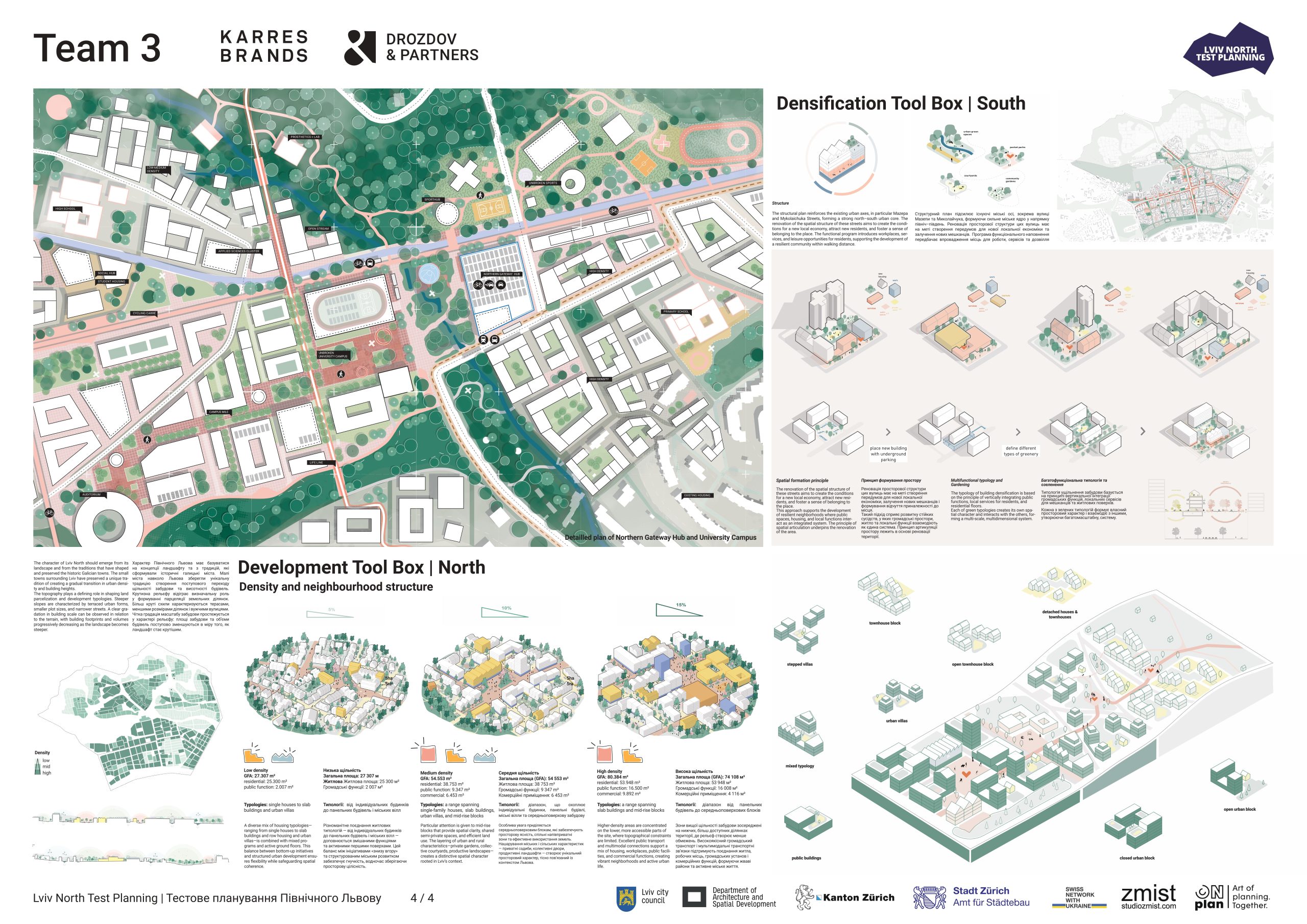
Typology and identity
The architecture draws on the traditions of Galician towns: human scale, terraced and cascading buildings that respond to the terrain. A range of typologies, from private houses to courtyard-style blocks, serves different lifestyles and income levels. The city is organized around hyperlocal neighborhoods within a 5-minute walk (300–400 m), each home to 1,000–3,000 residents.
A new building culture
Housing is treated as a flexible structure that can expand or be subdivided over time. Safety is built into the architecture through low- and mid-rise construction (less vulnerable to blast waves, faster evacuation). Energy autonomy, circular construction, and design-for-disassembly principles are built in as core sustainability standards. The team names the most important legacy of reconstruction not as buildings, but as the communities they sustain.
Images are shown here in compressed format. You can view and download the full high-resolution materials here.
Team 4
West 8 • Nederlands • + AVR Development • Lviv •
More about the team's concept
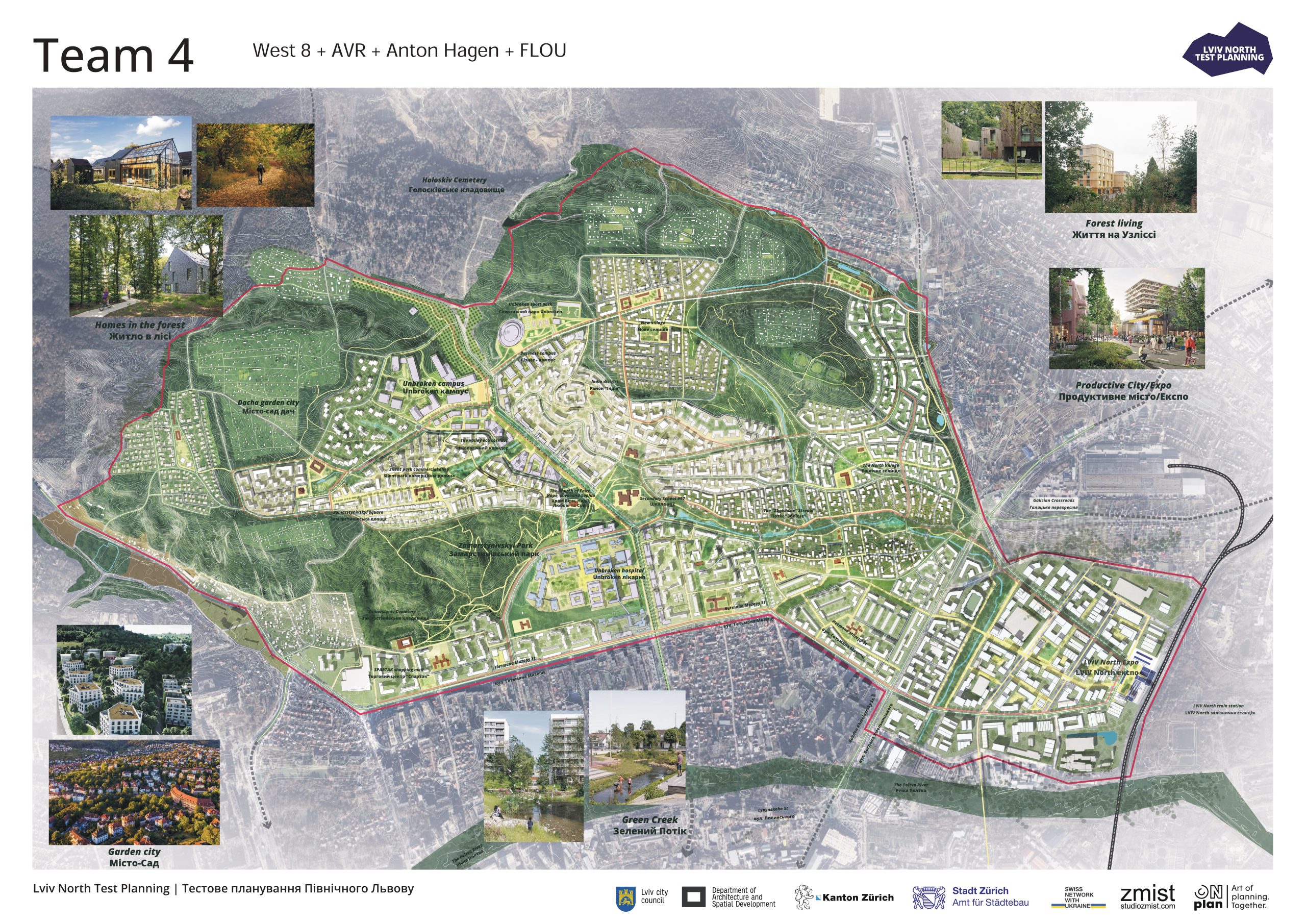
Garden City
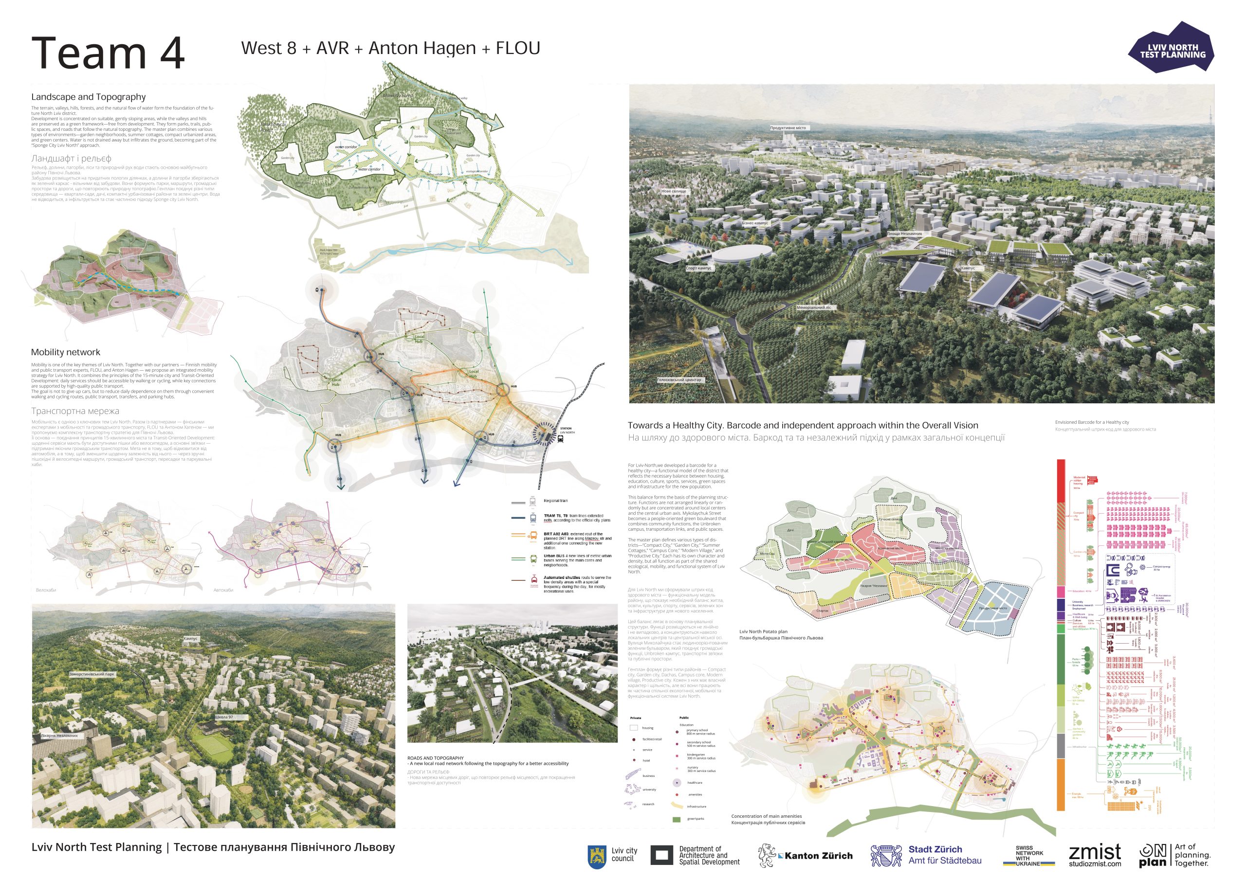
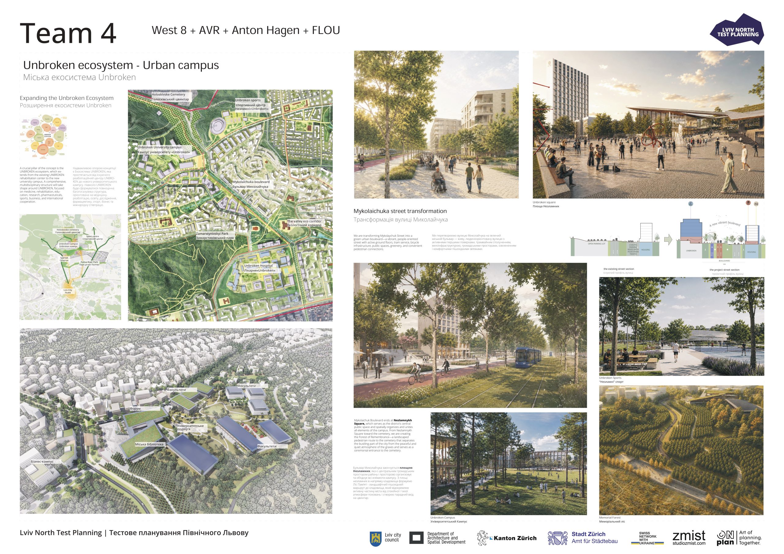
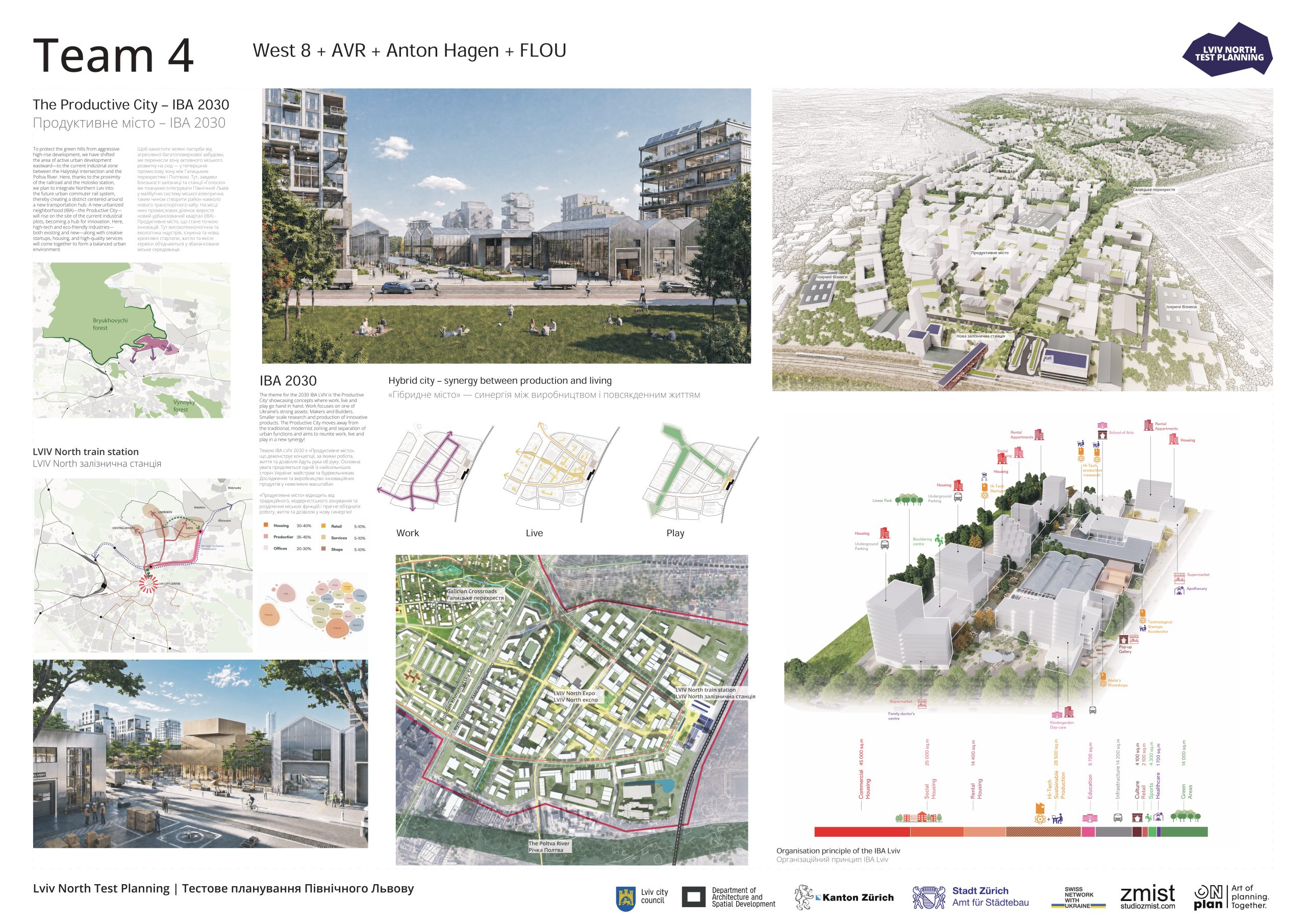
In the Garden City concept, the team treats North Lviv’s landscape as the starting point. Slopes, green corridors, and natural water flow form a landscape-water framework that shapes how streets and blocks are designed. The proposal calls for green buffers, a ban on development on hilltops, slopes, and water infiltration zones, and height limits to preserve panoramic views. Existing greenery and green areas are preserved and expanded wherever possible.
To protect the green hills from high-rise development, the team shifts active urban growth east, into the current industrial area between Halytskyi Junction and the Poltva. Thanks to its proximity to the railway and Holosko station, this area is well-placed to connect into the future urban rail system, with a new district forming around this transport hub. On the site of today’s industrial plots, a new urbanized quarter would emerge – the Productive City (IBA). It’s a hub of innovation, where high-tech and green industry, both existing and new, sit alongside creative startups, housing, and quality services in one balanced urban environment.
Another key pillar is the UNBROKEN ecosystem, stretching from the existing rehabilitation center to a new university campus. Around it, a multi-sector structure takes shape: medicine, rehabilitation, education, research, pharmaceuticals, sports, business, and international cooperation. Mykolaichuk Street becomes a green urban boulevard: a lively, people-first street with active ground floors, tram service, cycling infrastructure, public spaces, greenery, and comfortable pedestrian connections. The boulevard ends at Unbroken Square, the district’s central public space that ties together all elements of the campus. From there, toward the cemetery, a Memory Forest takes shape – a landscaped walking route separating the city’s active life from the quiet, contemplative atmosphere of the burial grounds, and forming a dignified approach to the cemetery.
Mobility is one of the project’s key themes. Working with partners – Finnish mobility and public transport experts, the FLOU, and Anton Hagen – the team proposes a comprehensive approach to transport infrastructure: public transit, pedestrian routes, cycling infrastructure, convenient transfers, and a new parking strategy for drivers.
At the same time, the concept calls for gradually renovating existing microdistricts at different scales, from improving courtyards and pedestrian connections to upgrading public spaces, ground floors, greenery, and mobility. One particular priority for the team is preserving the tradition of dacha-style development as an alternative form of urban living – quieter, closer to nature, with a different spatial scale and culture of everyday use.
The team also pays close attention to implementation tools: integrating the project into the city’s planning documents, improving funding transparency and quality, and setting a precedent for urban planning based on European practice.
Images are shown here in compressed format. You can view and download the full high-resolution materials here.
Team 5
Studio Vulkan • Цюрих • + ABMK • Львів •
More about the team's concept
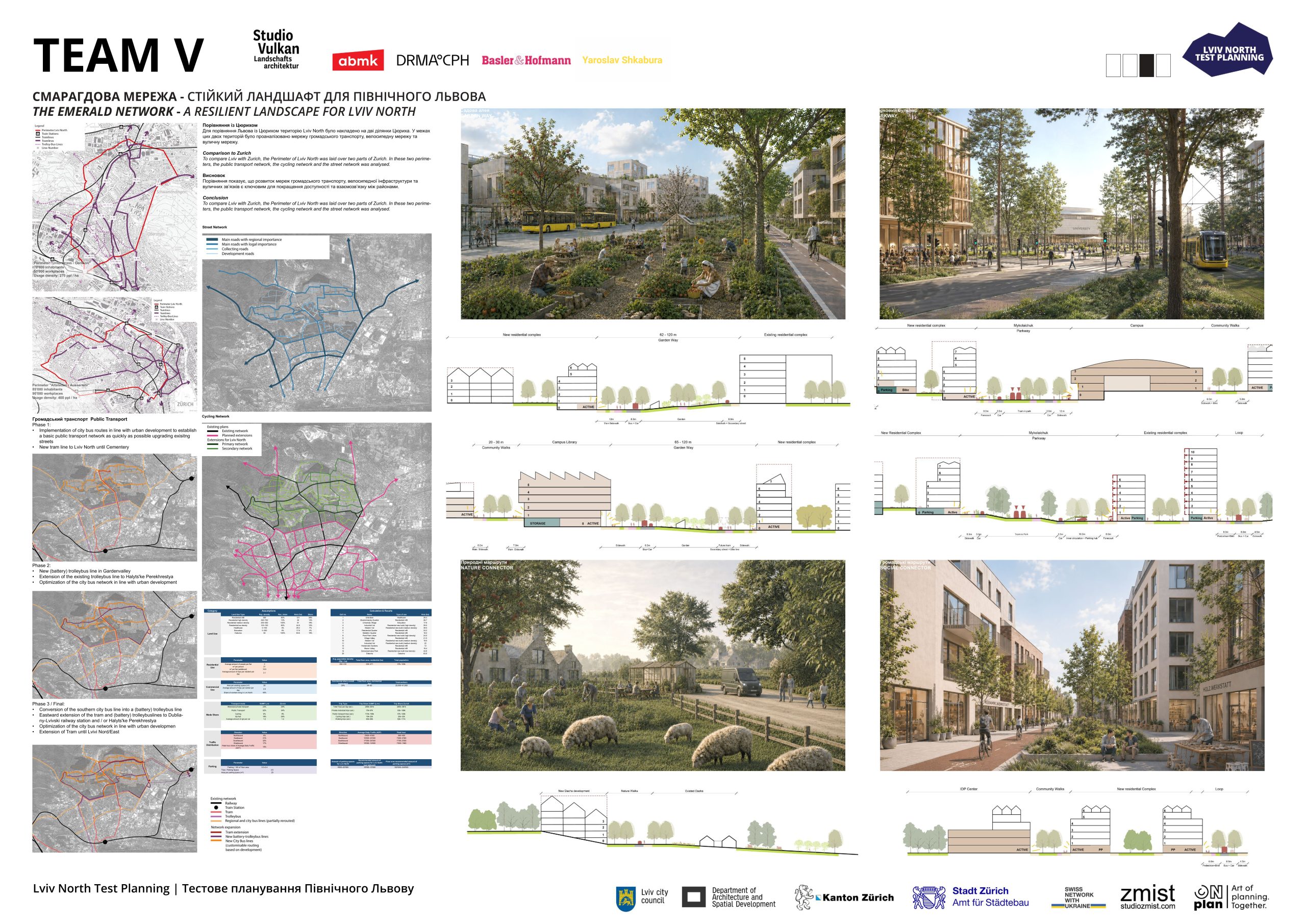
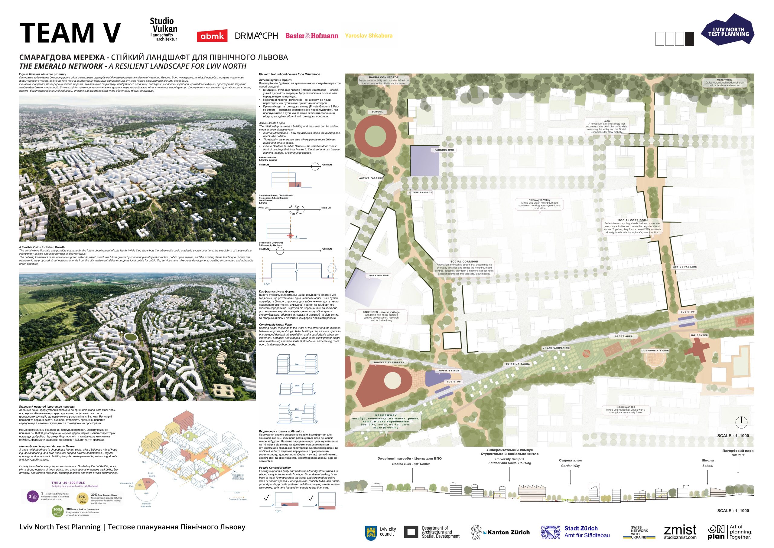
The Emerald Network
The concept is grounded in North Lviv’s existing conditions: a rolling landscape, a peri-urban character closely tied to the city, varied topography, historic cemeteries, an extensive healthcare network, and large dacha territories reflecting the region’s agricultural roots.
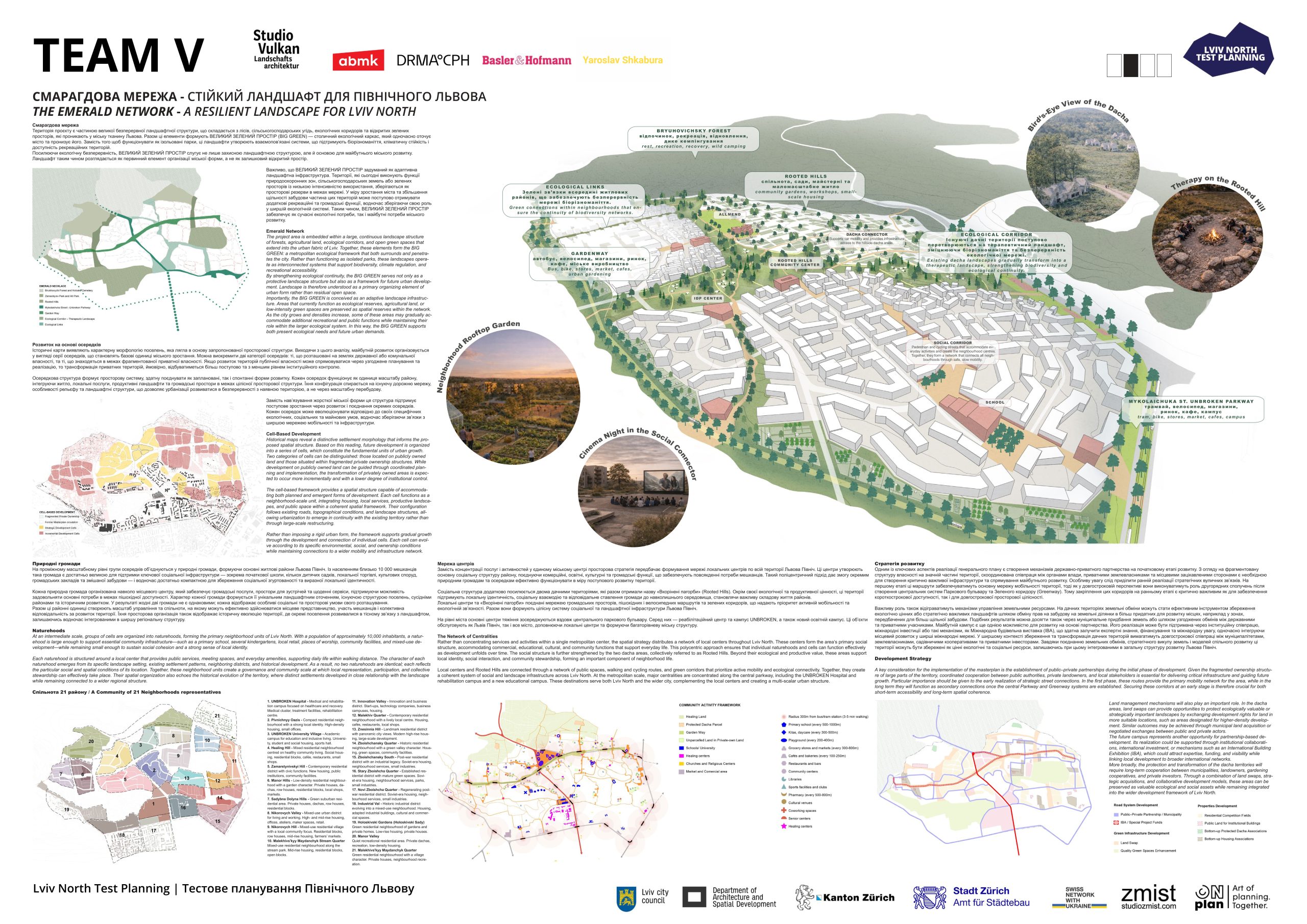
Rather than imposing a uniform structure, the strategy builds on existing patterns of land ownership, terrain, and movement. New neighborhoods form as differentiated settlement cells, each responding to local conditions while fitting into one overarching framework. The street network follows the same logic, growing from existing routes and reinforcing local spatial logic rather than introducing separate systems.
As urban researcher Yaroslav Shkabura notes, cities tend to grow through gradual transformation rather than complete reconstruction. New buildings rise where old ones stood, while street alignments and block configurations are often partly preserved. This lets expanding cities absorb surrounding settlements without erasing them from collective memory.
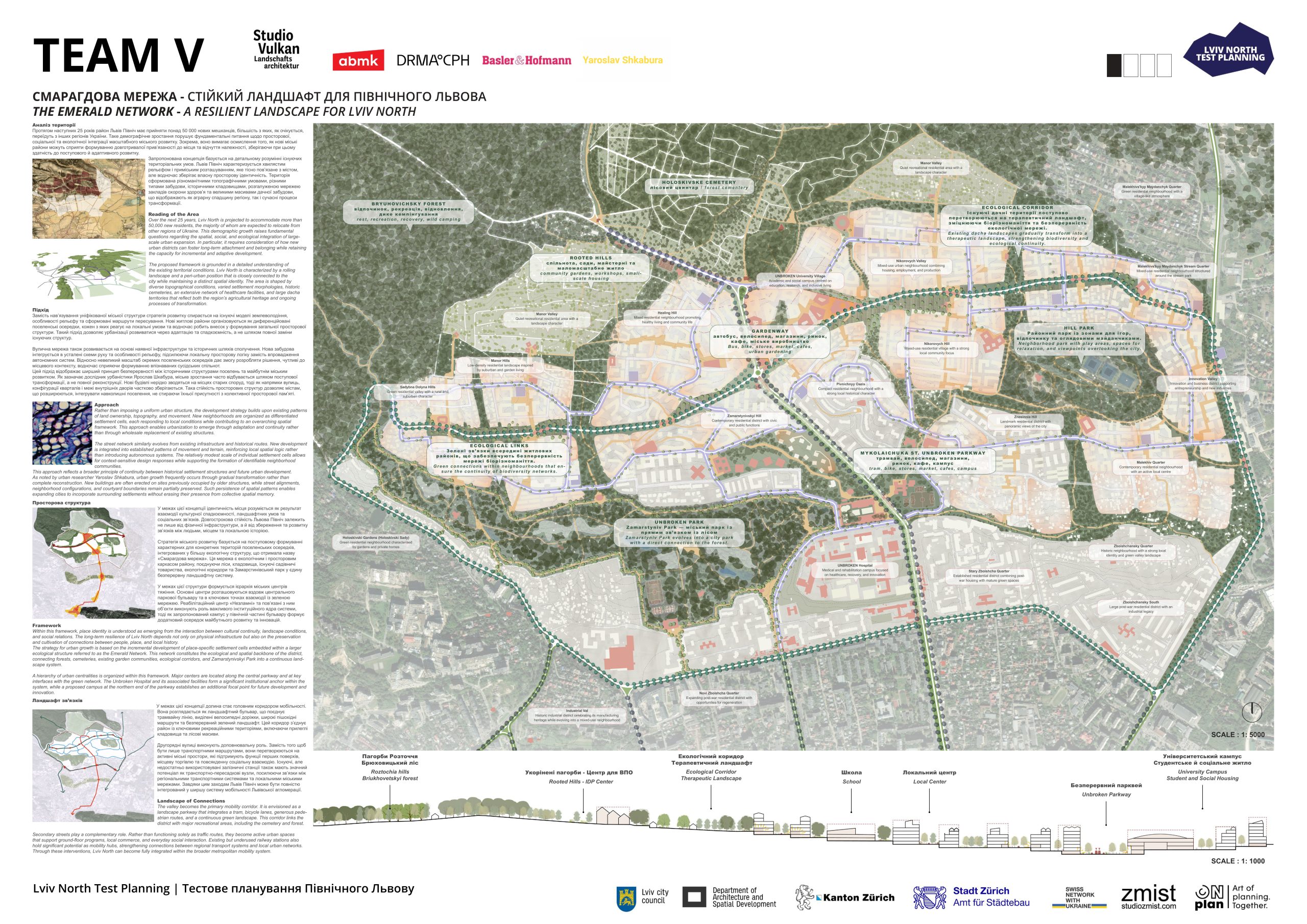
A place’s identity emerges from the interplay of cultural continuity, landscape, and social relationships. This underpins the district’s growth strategy: place-specific settlement cells embedded within a larger ecological structure – the Emerald Network. It forms North Lviv’s ecological and spatial backbone, linking forests, cemeteries, garden cooperatives, ecological corridors, and Zamarstynivskyi Park into one continuous system.
Within this structure, main urban centers sit along the central boulevard. UNBROKEN Hospital forms a major institutional anchor, while a proposed campus at the boulevard’s northern end creates an additional hub for innovation and future growth.
Mobility develops in three phases. Before a future tram corridor is built along the central boulevard, development concentrates on private land, supported by strengthened trolleybus services and on-demand shuttles. The second phase introduces the tram and coordinates development across public and private land. The third focuses on urbanizing peripheral areas and further expanding public transport.
Research by Yegor Vlasenko at EPFL highlights the importance of engaging with existing dacha territories — integrating them into the wider ecological framework rather than treating them purely as redevelopment sites. Working with gardening cooperatives opens the chance to rethink these areas as productive, therapeutic landscapes.
Development intensity follows local conditions: higher density near transport corridors and flatter terrain, lower density in ecologically sensitive areas. By combining place-based urbanization, ecological infrastructure, and phased implementation, the concept enables substantial growth while treating development as an evolving process — one where landscape, history, and community remain central to the city’s transformation.
Images are shown here in compressed format. You can view and download the full high-resolution materials here.